RUN THE BAY sponsored by TMNZ
Course Information
(Click map for more info)
6km Course Map

The 6km course starts and finishes at the Paihia Village green. Participants will navigate alongside the Paihia waters edge then up to then through the historic Waitangi Treaty grounds and loop back to finish back on the Village green. This event is perfect for individuals wanting to get a taste for events or families out to experience the taste of Paihia. The course consists of grass, metal, footpaths, and paved roads.
Footwear – Casual walking shoes for this event will suffice.
Elevation Profile:
- 64 m Total Ascent
- 65 m Total Descent
Aid stations situated at approx. 2.5km and finish (Water & Electrolytes)
Portaloos situated at 2.5km
Public toilets at the start/finish and at the 1km mark.
8.7km Course Map

The 8.7km course starts and finishes at the Paihia Village green. Much like the 6km event participants will navigate alongside the Paihia waters edge. You will make up the Km's and additional elevation on the 6km event by tackling the gradually ascending road that will head up past the Waitangi Golf Course, once you've taken in the breathtaking views that the bay of islands has to offer you will then loop back around towards the finish area via the historic Waitangi Treaty grounds to the Village green. The course consists of grass, metal, footpaths, and paved roads.
Footwear – Running shoes for this event will suffice as the majority of the course is roads and footpaths.
Elevation Profile:
- 139 m Total Ascent
- 139 m Total Descent
Aid stations situated at approx. 5.5km, and finish (Water & Electrolytes)
Portaloos situated at 5.5km
Public toilets at the start/finish and at the 1km mark.
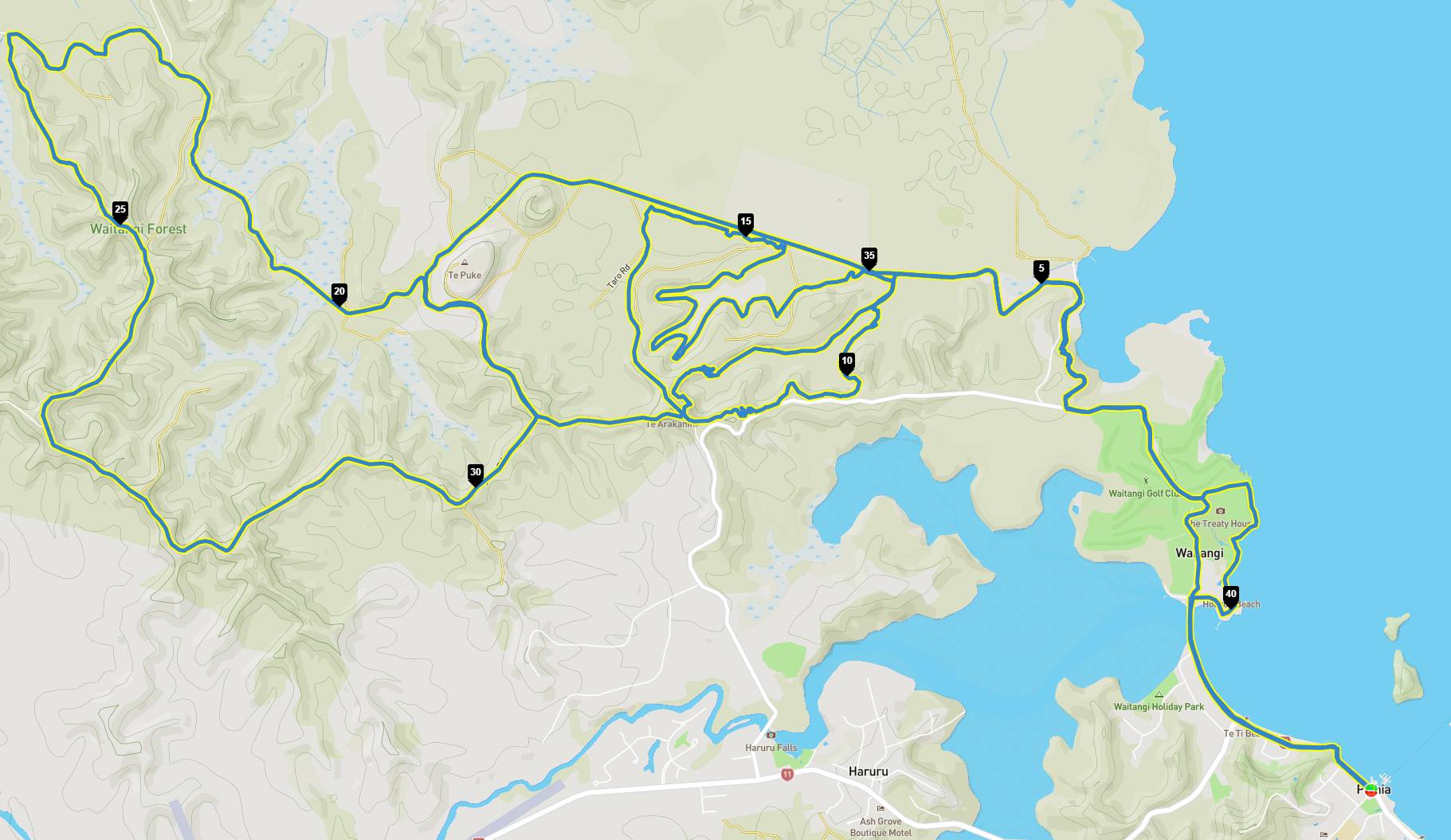
22km Half Marathon Course Map

This Half Marathon Course takes you along the same route as the 8.7km course past the Waitangi Golf Course; instead of turning around and heading straight down the hill to the finish, you'll navigate to the Waitangi Mountain Bike Park via the Wairoa track and head into the Waitangi Forestry. During your time in the Waitangi forest, you'll have an exclusive opportunity for this event only to run along some of the Mountain Bike trails that the Waitangi Mountain Bike Park has to offer; you'll run the forestry roads and loop back through the Waitangi Mountain Bike Park and head towards the finish area via the historic Waitangi Treaty Grounds to the Village Green.
Footwear – The majority of the course is roads and footpaths. We recommend wearing Trail shoes due to the unpredictable surface conditions within the Waitangi Mountain Bike Trails.
Elevation Profile:
- 318 m Total Ascent
- 319 m Total Descent
Aid stations situated at approx. 3km, 5.5km, 12km, 16.5km, 19km. (Water & Electrolytes)
Portaloos are situated at 3km, 12km and 19km.
Public toilets at the start/finish and at the Waitangi Mountain Bike Park (5.5km & 16.5km)
There are no cups through the Waitangi Forest
To help protect the environment and reduce our footprint, we’ve eliminated disposable cups from the course. As part of your race prep, you should carry a trail pack with all essentials, including your own hydration system or a reusable cup.
Trek Trail & Fish Full Marathon Course & Map
This Marathon Course follows the same opening route as the shorter distances, taking you past the Waitangi Golf Course before continuing along the coastline. Rather than turning back, runners will push on towards the Waitangi Mountain Bike Park via the Wairoa Track, entering a mix of flowing single track and forestry roads.
From here, the course extends deeper into the Waitangi Forest, where runners will experience an exclusive opportunity to cover a wide network of mountain bike trails, including more technical and remote sections not used in the shorter events. The route winds through native bush, rolling hills, and purpose-built trails before looping further out into the forestry, offering a true test of endurance.
After completing the outer forest loops, runners will retrace sections back through the Waitangi Mountain Bike Park and reconnect with the coastal route. The final stretch takes you back past the Waitangi Treaty Grounds, finishing on the Village Green.
This course is designed to challenge and reward, combining coastal scenery with extensive trail running through one of Northland’s premier trail networks.
Footwear – The majority of the course is roads and footpaths. We recommend wearing Trail shoes due to the unpredictable surface conditions within the Waitangi Mountain bike Trails.
Elevation Profile:
- 1,015 m Total Ascent
- 1,015 m Total Descent
Aid stations situated at approx. 3km, 5.5km, 19km, 27km, 32km, 36.5km, 39km and at the finish area. (Water & Electrolytes)
(The aid station at the 19km and 32km will contain water, electrolytes, salted chips, lollies, oranges & Flat coke)
Portaloos are situated at 3km, 19 km, and 27km.
Public toilets at the start/finish and at Waitangi Mountain Bike Park (5.5km & 36.5km)
There are no cups through the Waitangi Forest
To help protect the environment and reduce our footprint, we’ve eliminated disposable cups from the course. As part of your race prep, you should carry a trail pack with all essentials, including your own hydration system or a reusable cup.