
North Mississippi’s Premier Cycling Event
Oxford, MS
Saturday
August 8th, 2026
The wait is over. Oxford MS has experienced the historic ice storm last Winter. Clean-up work for the streets is coming to an end. We welcome you back to the 2026 Velvet Ditch Grand Fondo cycling event. This year we have moved the date to August 8th and thank you to the Lafayette County and city of Oxford, we have a new road riding out this year. It will be a less hilly start.
The Velvet Ditch Gran Fondo is a non-competitive bicycle ride, meaning there will be no awards for fastest times. The ride will take place on open roads, so rider discretion is advised.
As long as you want to pedal, all bikes are welcome: Big Box Bikes, Commuter bikes, E-bikes, Gravel bikes, Mountain bikes, Recumbent bikes, Road bikes, Tandem bikes, etc.
What are new this year
- Starting time: 7:00am to start for the Summer temperature
- Start location: The concession stand of the mTrade park at 328 Old Sardis Rd, Oxford, MS 38655. https://maps.app.goo.gl/qwSKpVAnzxTToziF9
- Finish location: The pavilion at the mTrade Park. https://maps.app.goo.gl/9XYrK62E3Gnq9YG89
- Routes: All routes have updated due to new start/finish location
- Packet pick up location: The pavilion at the mTrade Park. https://maps.app.goo.gl/9XYrK62E3Gnq9YG89
- Pricing: Simplified and more affordable
2026 VDGF Merchandise
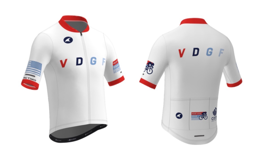
The 2026 VDGF jersey is available in the event store. It can be purchased during registration or after the registration.
Fundraising
Proceeds of this ride will support the North Mississippi Gnarmadillos Composite MTB Team. This team is made up of middle and high school mountain bikers from the Oxford and North Mississippi area. More information about the team can be found on their Facebook page, https://www.facebook.com/NorthMSGnarmadillos/. You can support the team by making a donation at https://raceroster.com/events/2026/122466/velvet-ditch-gran-fondo-2026/fundraising-organization/91963
A check will also be donated toward the on-going maintenance of the Tanglefoot Trail during the Tour de Bodock Bicycle Ride.

The Yalobusha Greenways Alliance (YGA) is working to build a connected, bikeable, walkable pedestrian trail that spans from Water Valley to Oxford to the north, Coffeeville to the south, and beyond. You can support this project by making a donation at https://www.yalobushagreenways.org/donate
Check out Visit Oxford’s website for lodging, dining, and other attractions around town: https://visitoxfordms.com
FAQ - Frequently Asked Questions
Registration
- Online registration closes at 6:00AM on August 8th Central Time.
- Registration includes an event T-shirt, a pair of socks, and some goodies from our sponsors. Don't forget to register early to guarantee T-shirt size.
Packet Pick-up
- Location: The Pavilion at the mTrade Park
- Time:
- Friday, August 7th (5:00 PM - 7:00 PM)
- Saturday, August 8th (5:30 AM - 6:30 AM)
Age Restriction
- There is no age restriction for this event. Anybody of any age can ride. Age of 18 or under gets 50% discount on registration fee.
Registration fees
Where pricing applies, shown amounts include mandatory charges, items, and fees.
22 Miles Route Closed
-
$28.79Apr 26 - Aug 8
46 Miles Route Closed
-
$56.33Apr 26 - Aug 8
VDGF Metric Century Closed
-
$56.33Apr 26 - Aug 8
VDGF Gravel Route Closed
-
$56.33Apr 26 - Aug 8
Course Map
22-mile Route
Clocking in at 22.2 miles, this route is an out-and-back route with a SAG stop and turn around point at Smith’s Chapel, just outside the Holly Springs National Forest.
Ride with GPS link: https://ridewithgps.com/routes/54825769
46-mile Route
Clocking in at 46.4 miles, this route will continue beyond Smith’s Chapel, traversing up to Abbeville, over to Hurricane Landing, where it has another SAG stop. Then riders take the Old Sardis Road back to mTrade park.
Ride with GPS link: https://ridewithgps.com/routes/54825779
VDGF Metric Century Route
It is not a typical metric, it is a VDGF kind of metric. Clocking in at 66.5 miles, this is the longest route of the event. It is an extension of the 46-mile route, head out and come back from the Clear Creek Landing area. Riders will turn around at the Clear Creek Recreation Area sign, where it has another SAG stop.
Ride with GPS link: https://ridewithgps.com/routes/54825780
VDGF Gravel Route
We have a brand new option for the gravel nuts amongst us. We know you all miss the gravel cup series… well now you can ride a section of the OMG course, but instead of freezing you’ll be sweating! Enjoy the shade, beautiful scenery, and the lack of traffic in the Holly Springs National Forest.
This course is 57 miles long and approximately 35% gravel. The gravel route follows the metric century road route until Mile 16, where it splits off.
There are three gravel sections:
- Mile 21-31
- Mile 37-39
- Mile 45-48
Between these sections the gravel course re-joins the metric century road course.
The gravel in Lafayette County is NOT easy. This isn’t a tame rails-to-trails situation. Our gravel can be deep and slippery, and the roads- while overall in good condition- do have some pot holes and big ruts. There are hills, so be prepared to descend and corner on loose gravel. There are also a few sandy sections. Most riders in this area have tires that are at least 40mm wide if not 45-55mm wide. Also, there can be a lot of bugs this time of year so bug spray is recommended.
Water: Mile 11, 32, and 51. Mile 32 is a water drop/cooler (unmanned). There is also a gas station in Abbeville on Highway 7 not far from the course (around mile 33).
**It is imperative that you bring enough water and electrolytes- overestimate what you need. We recommend at least 2 large bottles and/or a hydration backpack**
Bike: A gravel bike or hard tail mountain bike is necessary for this route.
Route: Download the route. We will do our best to mark the turns with spray painted arrows. We will also mark any enormous holes, but please be safe and ride carefully at all times.
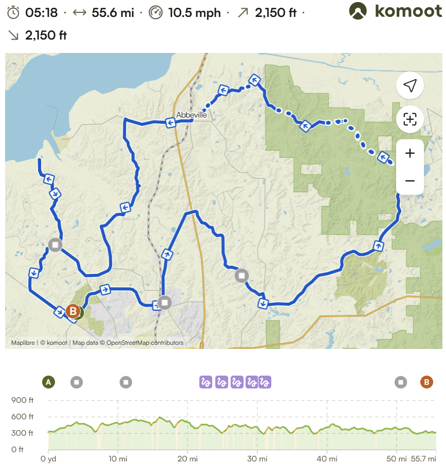
Ride with GPS link: https://ridewithgps.com/routes/56218063
Video
Contact information
- Event contact
- Claude Gunter
- Phone
- +1-601-416-5244
- Website
- Visit website


